ARCHEOASTRONOMIA LIGUSTICA
Pubblicato in: Atti del XI Convegno Società Italiana di Archeoastronomia, Il dentro e il fuori del cosmo. Punti di vista per interpretare il mondo. Bononia University Press, Bologna, 2013, pp. 67-75, ISBN 978-88-7395-866-6.
Printed in: Atti del XI Convegno Società Italiana di Archeoastronomia, Il dentro e il fuori del cosmo. Punti di vista per interpretare il mondo. Bononia University Press, Bologna, Italy, 2013, pp. 67-75, ISBN 978-88-7395-866-6.
ARCHAEOASTRONOMICAL SURVEYS IN
TURKMENISTAN
Barbara
Cerasetti
Dip. Storia, Culture, Civiltà, Università di Bologna; barbara.cerasetti@unibo.it
Mario
Codebò
Archeoastronomia Ligustica; S.I.A.; S.A.It.; info@archaeoastronomy.it
Henry De Santis
Archeoastronomia Ligustica; S.I.A.; S.A.It.; info@archaeoastronomy.it
1. Archaeological
introduction (by Barbara Cerasetti)
At the beginning “The Archaeological Map of the
Murghab Delta”[1]
was designed to carry out the systematic recording of
sites and palaeochannels across the Murghab alluvial fan, to reconstruct
landscape and settlement variations, before most of them would disappear for
the expanding irrigation works from the Karakum[2] canal. The activities of the project, beginning in 1990 and
continuing through the present, have coexisted with, and had to adapt to, the
deep environmental change brought about by the expansion of cultivated land and
the strategies and methods of archaeological field work had to change
gradually. The archaeological survey activities were initially concentrated in
the southern part of the alluvial fan of the Murghab river and characterized by
a great intensity. Only later on, the activities were extended to the rest of
the fan and it was then possible to significantly enrich the catalogue of the
archaeological sites, with the help of aerial photograph coverage and satellite
images. The aim was to produce some reconstructions of the ancient river system
and of the old branches of the Murghab that were active during the 3rd,
2nd and
1st millennia
BC, and to establish a relationship between them and the peopling dynamics in
that area.
Turkmenistan is approximately 488 km2 in size, 387
km2 of
which are covered by ten different types of deserts. The Paropamiz and Kopet Dagh
mountain ranges and plateaus frame the country’s south-western border. The main
rivers are the Amu Dar’ya, Tejen and Murghab. The
source of the latter river lies in the Hindukush of Afghanistan and it
transverses Turkmenistan from south to north and flows through the
south-eastern desert of the Karakum. Progressively dryer climatic
conditions and resulting desertification have greatly reduced the extent of the
Murghab alluvial fan over the past five millennia. For this reason, the
majority of archaeological sites are now located in the desert.
Fifteen years of surface survey in the Murghab
alluvial fan have demonstrated the importance of GIS technologies to
reconstruct the profiles of the ancient landscapes in this region and to
collect more then one thousand archaeological sites. By employing historical
maps and survey transects integrated through orthophotography from aircraft and
space as well as oblique flights, we have been able to gain a much better
understanding of the ancient landscape of the Murghab river[3].
For the present research, concerning investigations to
detect the archaeoastronomical measurements of the architectural structures in
the ancient time, we selected four archaeological sites, respectively
Gonur-depe (Middle Bronze Age-MBA
2. Archaeoastronomical surveys (by Henry De Santis)
The outcomes of the archaeoastronomical surveys
that we present here concern structures and buildings of the following sites:
·
Gonur-depe
and Gonur South (Themenos)[8];
·
Togolok
21;
·
Ancient
Merv.
The measurements – got by a graduated spherical surveyor’s
cross that determines
astronomically (i.e. very accurately) the azimuths of the surveyed objects – are based on the
relative immutability of Sun and Moon seasonal positions on the skyline for several millennia. This is not the case of the stars! Indeed, their positions change
considerably (about 1° in 72 years) and it is necessary to develop long and complex
calculations to reconstruct
their secular movements. Moreover, possible settings in a row of stars must be
estimated by probabilistic methods.
Gonur-depe
We measured this site from the structure of the internal walls surrounding the palace and the ruins of the palace. The east and west walls are oriented along the N-S line, with a medium axes of 2°16’ « 182°16. The northern side of the walls are oriented along the E-W line with an azimuth of 89°46’ « 269°46’. On the other hand, only the southern wall was built with a little digression in azimuth, quantifiable at about 6.5 degrees (275°44’). This difference could be intentional and this subject deserves further research. The walls inside the ruins, as well as the palace, were built almost exactly in orientation with the four cardinal points (azimuth 0°41’ « 180°41’ and 90°41’ « 270°41’).
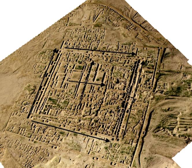
Fig. 1 - The
settlement of Gonur-depe with indication of measurements
(photo by G. Davtian, published with kindly
permission of V.I. Sarianidi and N.A. Dubova)
Gonur South (Themenos)
More interesting are the reasons of the building of this alleged observatory,
because from the interior it is possible
to observe several Moon positions and one Sun specific position. In details:
- The
internal walls are oriented approximately N-S-E-W, with an azimuth of 351°
« 171° and 81° « 261°. These differences from
meridian and equatorial axes are the result of a precise research,
carried out by the
builders using positional
astronomy. As I discussed briefly, these
orientations let the observer
see many
astronomical phenomena.
It was not possible to take astronomical
measures of the more external walls because of the poor conservative state of these structures, but they reflect basically
the orientations of the internal perimeter.
- Towers
of the corners of the walls:
a) NW tower corner: set to match the Moon at its northern utmost
amplitude[9] (a.k.a. Moon Solstice), a position the
satellite gets every 18,61 years. It has been
proved that this astronomical phenomenon was known in ancient times;
b) NE and SW tower corners:
exactly the opposite; maybe it was possible to observe the rising of a star or of a constellation. Further researches
are needed to test
the authenticity of these alignments;
c)
SE tower corner: rise of the Moon at its southern utmost amplitude, the other
position that it
reaches every the above mentioned cycle of 18,61
years.
- Intermediate
towers at the centre of each single side:
a) N side. NW tower: Moon setting at its
northern utmost amplitude; NE tower: still doubtful at the moment; probably stars;
b) S side. SW tower: still doubtful at the moment; probably stars; SE tower:
Moon rising at its southern utmost amplitude;
c) E side. NE tower: still doubtful at the moment; probably stars; SE tower:
Sun rising at winter solstice;
d) W side. NW tower: Moon setting at its
northern utmost amplitude; NE tower: still doubtful at the moment; probably stars.
It is possible to infer that the Themenos of Gonur South is a Moon and Sun observatory. Now we are developing the calculations related to stars and constellations.
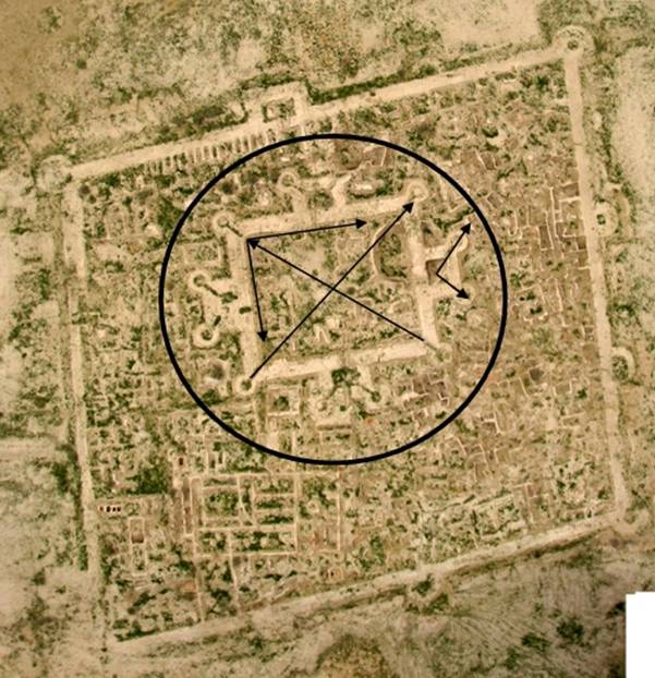
Fig. 2 - The alleged observatory of Gonur South with indication of measurements
(photo by G. Davtian, published with kindly
permission of V.I. Sarianidi and N.A. Dubova).
Togolok 21
The
astronomical survey of the town and external perimeter
walls shows that
they are oriented, almost exactly, towards the four
cardinal points (azimuth 359°17’ 179°17’ and 90°
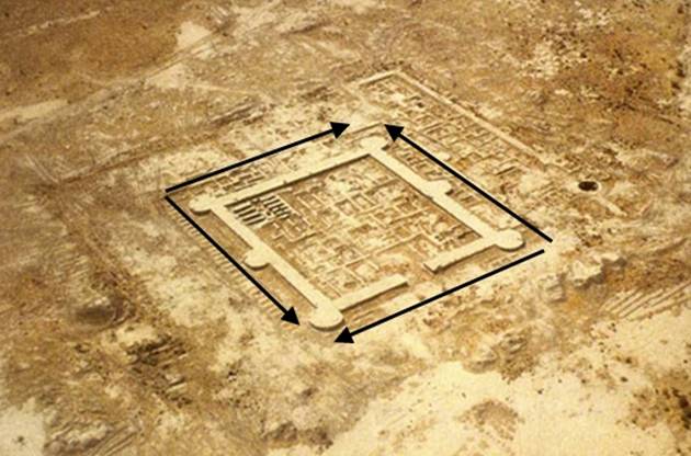
Fig. 3 - The archaeological complex of Togolok 21 with
indication of measurements
(photo published with kindly permission of V.I.
Sarianidi and N.A. Dubova).
Ancient Merv
The Big Kiz-kala was built to match both the direction of the summer solstitial sun rising and the winter solstitial sun
setting. It is possible to observe these positions through the big holes in the
walls of the structure.
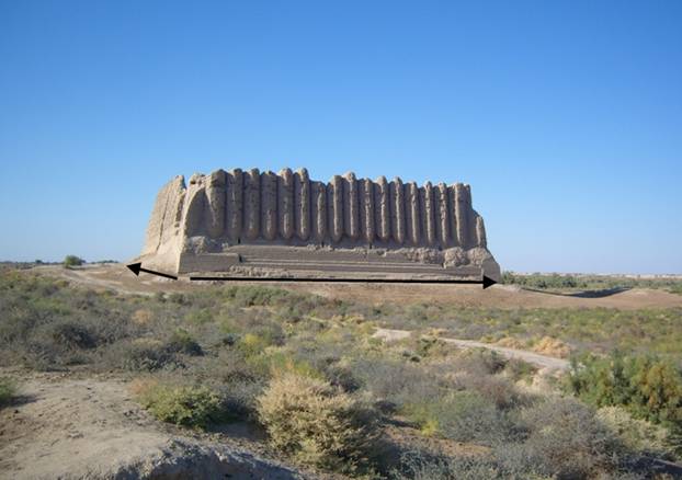
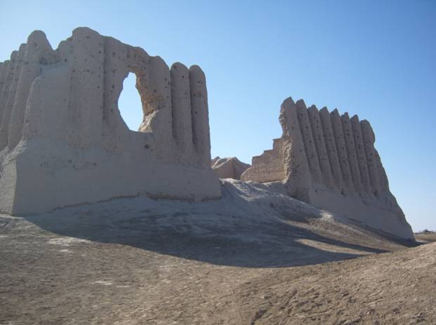
Figs. 4-5 - The Big
Kiz-kala fortress (photos by H. De Santis).
The minor axes of Shahryar Ark’s building are roughly oriented like the
equinoctial line, with an azimuth of 96° « 276°.
Finally, the Imaret-Pavilion does not match particular directions, but
was roughly built towards the summer solstitial sun rising and the winter
solstitial sun setting with an error of 6°.
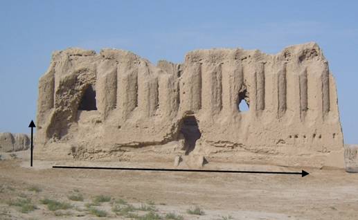
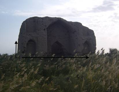
Figs. 6-7 The Shahryar Ark palace (left side) and the
Imaret-Pavilion (right side) with indication of measurements (photos by H. De
Santis).
3. Conclusions (by Mario Codebò)
The most interesting outcomes are the azimuths
of Gonur-depe and Togolok 21. The Azimuth difference among east and west walls
of Gonur–depe and Thuban (α Draconis) in 2400 BC (Thuban’s maximum
digression[10]
was 2°51’26.25”) is only 0°35’26.25”. Therefore we can think that, like in
Lothal[11],
the builders got this setting in a row using the Polar Star of their age, i.e.
Thuban[12].
These orientations do not seem random. As I wrote in another my report[13],
there are several methods to point a building towards the four cardinal points[14],
but only the stars get the best outcomes. The most careful N-S orientation of
the walls inside the ruins could be got by observing the upper and lower
culmination of Thuban instead of its maximum digression.
Because Togolok 21 belongs to the same cultural
horizon, although half millennium more recent, we can think – like a working
hypothesis - that the four cardinal point setting in a row was a local
uninterrupted tradition.
There are other monuments oriented towards the
four cardinal points:
1) Lothal axes in India (2450-1900 BC)[15];
2) the Egyptian pyramids of Giza (2650-2400 BC)[16];
3) the quadrangular cromlech of Crocuno in
French Brittany (3000-1500 BC)[17];
4) Callanish south standing stones row in the
Scottish isle of Lewis, 1500 BC.[18];
5) the Campuriundu stones circle in Finale
Ligure, Italy (date unknown)[19];
6) the dolmen - with its corridors - of
Roccavignale, Savona, Italy (date unknown)[20];
7) the Carahunge stones setting in a row in
Republic of Armenia (5th or 3rd millennium BC) [21];
8) the Etrurian town of Marzabotto – 5th
century BC - in Italy[22].
Leaving out the monuments with
uncertain (Nos. 3[23],
5, 6) or later (Nos. 4[24],
8) age, the alignments towards the four cardinal points seem to be a widespread
tradition in the 3rd millennium BC, although less followed in
Europe. Indeed, European megalithic monuments were oriented towards solstitial
and lunistitial points much more frequently. A working hypothesis is that
Egyptian[25]
and Asian peoples knew already the equinoctial precession, whereas European
peoples, unaware of it, used only Sun and Moon movements to measure the time. A
long research of mine, with two others authors (Bianchi E. e Veneziano G.), is
showing that ancient middle Eastern peoples knew and used probably the
equinoctial precession since the 4th millennium BC[26].
Moreover, it is well-known that China, according to its ancient and
autochthonous religion, is in the middle of the four cardinal points and the
polar axis.
Therefore it needs to look for other cardinal
alignments and to reflect, if found, on their meaning and incidence on the
ancient cultures, particularly in the 3rd millennium BC.
References Cited
Burl A. (1993), From Carnac to Callanish, Yale University Press, New Haven and
London.
Cerasetti B. (2012), Remote Sensing and Survey of the Murghab Alluvial Fan, Southern
Turkmenistan: The Coexistence of Nomadic Herders and Sedentary Farmers in the
Late Bronze Age and Early Iron Age. In Matthews
R. - Curtis J. (eds) Proceedings of the 7th International Congress on
the Archaeology of the Ancient Near East 12 April –
Codebò M. (1997), Prime indagini archeoastronomiche in Liguria, Memorie S.A.It., 68(3), 735-751.
Codebò M. (in press), Il calcolo FK4 B1950.0 della precessione delle stelle, Atti del XIII Seminario A.L.S.S.A. di Archeoastronomia, Genova.
Codebò M. (submitted), The knowledge of the aequinoctial precession before Hypparcus, Atti S.I.A. 2009.
Codebò M. - De Santis h. - Frenez D. (submitted), Archaeoastronomical surveys in Lothal, Atti del XI convegno S.I.A.
Cossard G. (1993), Le pietre e il cielo, VECO, Cernobbio (CO).
Gubaev A. -
Koshelenko G. - Tosi M.
(eds) (1998), The Archaeological Map of the Murghab Delta, Preliminary Reports 1990-95, Reports and
Memoirs, Series Minor, III, Roma.
Hadingham E. (1978), I misteri dell’antica Britannia, Newton & Compton, Roma.
Herrmann G. (1999), Monuments of Merv: traditional buildings of the Karakum, Reports of the Research Committee of
the Society of Antiquaries of London, London.
Herouni P.
M. (2004), Armenians and old Armenia, Yerevan.
Herouni P. M. (2009), L’osservatorio preistorico di Carahunge in Armenia. In Codebò M. (ed.), Atti del Convegno Internazionale “Archeoastronomia: un dibattito tra archeologi ed astronomi alla ricerca di un metodo comune”, I.I.S.L., Bordighera (IM), 88-95.
Kozhein P. M. – Kosarev M. F. – Dubova N. A. (eds) (2010), On the Track of Uncovering a Civilization. A volume in honor of the 80th-anniversary of Victor Sarainidi. Transactions of the Margiana Archaeological Expedition. Sankt-Petersburg.
Magli G. (2005), Misteri e scoperte dell’archeoastronomia, Newton & Compton, Roma.
Meeus J. (1990), Astronomia con il computer, Hoepli, Milano.[27]
Proverbio E. (1989), Archeoastronomia, TETI, Milano.
Romano G. (1992), Archeoastronomia Italiana, C.L.E.U.P., Padova.
Ruggles C. (1999), Astronomy in prehistoric Britain and Ireland, Yale University
Press, New Haven and London.
Salvatori
S. - Tosi M. (eds)
(2008), The Bronze Age and Early Iron Age in the Margiana Lowlands. Facts
and Methodological Proposal for a Redefinition of the Research Strategies. The
Archaeological Map of the Murghab Delta, Studies and Reports, II, British Archaeological Reports
1806, Oxford.
Sarianidi V. I. (1990), Drevnsoti strany Margush. Askhabad.
Sassatelli G. (1992), La città etrusca di Marzabotto, Grafis Edizioni, Casalecchio di Reno (BO).
Schiaparelli G. V. (1998) Scritti sulla storia dell’astronomia antica, vol. 3, Mimesis, Milano.